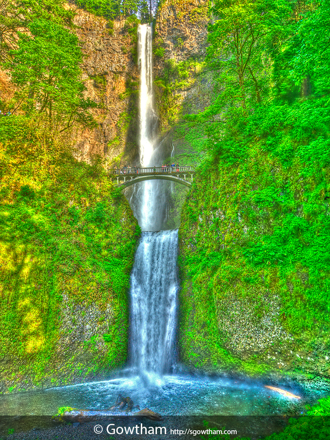
Reservation efforts in the Columbia River Gorge began long before the 1986 National Scenic Area Act. During the early 1900s, advocates for a scenic highway recognized the beauty of the gorge should be preserved for future generations. Upon completion of the Historic Columbia River Highway in 1915, generous land owners donated property to create scenic retreats along the route. Timber tycoon Simon Benson donated the site of Multnomah Falls along with 300 acres, including Wahkeena Falls, to the city of Portland in 1915.
Located along the Columbia River Highway (off of I-84) between Corbett and Dodson, Multnomah Falls is the second highest year-round waterfall in the US and one of 77 (yeah, seventy seven) on the Oregon side of the Columbia River Gorge. Multnomah Creek – which in turn is powered by underground springs from Larch Mountain – and the seasonal snowmelt/rainfall power the falls as it plunges off steep basalt cliffs – 543 feet to the upper pluge pool, descend another 69 feet for a grand total of 620 feet.
EXIF and other information
| Archive ID | n21_108-4598 |
| Date and Time | 2010-05-31 21:18:45 |
| GPS Date and Time | Image does not include relevant information |
| GPS Location | 45.57676 N, -122.11663 E, 60 ft (Goolgle Map: Pin | Directions) |
| Camera | Nikon D200 |
| Lens | AF-S DX Zoom-Nikkor 12-24mm f/4G IF-ED |
| Focal Length | 14.0 mm (35 mm equivalent: 21.0 mm) |
| Mode | Aperture-priority AE |
| Shutter Speed | 1/80 second(s) |
| Aperture | f/11.0 |
| ISO | 400 |
| Exposure Bias | 0 |
| Flash | No |
| Filters | None |
| Light Value | 11.2 |
| Hyperfocal Distance | 0.89 m |
| Focus Distance | 1.50 m |
| Depth of Field | inf (0.56 m - inf) |
| Field of View | 80.7 deg (2.54 m) |
| Tripod | Yes |
| Notes/Remarks | ±2 stop and HDR using Photomatix Pro |


